The Towns of the Cinque Terre
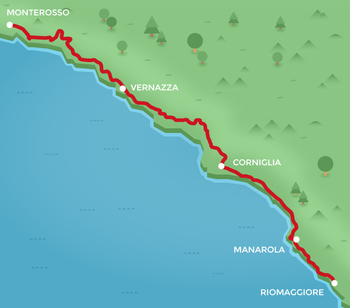
- Riomaggiore – Monterosso
- Difficulty 1
- Time 4h30′
- Length 10,2 km
The itinerary enters the Cinque Terre National Park and winds along the terraced lands and villages which were put under the protection of the UNESCO as a World Heritage Site owing to the incredible equilibrium reached over the centuries by the inhabitants with their environment, represented by steep slopes with terraced vineyards down to the sea, one of the most characteristic features of the land.
But in addition to its quality wines and Sciacchetrà, a dense full-bodied sweet wine, the Cinque Terre also captivates visitors with its great seafood dishes, first and foremost the Monterosso anchovies and specialities based on juicy yellow lemons that ripen perfectly in the setting sun. If we leave the table and put on our trekking shoes, we can visit all the villages of the Cinque Terre by following a single trail. It is marked as number 2 on the map and starts in the square behind the Riomaggiore train station. The first part is the renowned Via dell’Amore (Lovers’ Walk). On arriving at Manarola we turn left in the direction of the marina below the Punta Bonfiglio park. At the spot where the old and new stretches of trail 1 meet, it becomes a flat dirt road and follows the beach of large rounded stones at Corniglia, where the waters of the marine protected area show off all their crystal clearness.
After passing the Corniglia train station we go up the “Lardarina” steps to the village. The trail passes along the outside of the old centre, where vineyards alternate with vegetable gardens and olive trees, another characteristic feature of the landscape, with their fruits an essential part of the local cuisine. We cross the Rio della Groppa and arrive above the beach at Guvano. Leaving behind us the cliffs at Macereto covered with agave and cactus, we come to the crossroads with trail number 7 and once again find the terraced vineyards basking in the sun where we catch site of the highest towerof Vernazza. Further on, the trail continues at 150 to 200 metres above the blue sea.
On approaching Monterosso, the terraces become more and more populated with citrus groves: we are entering the realm of the Monterosso lemons celebrated with a festival every year on the third Saturday of May. But at this point we must not give in to fatigue but decide to go on to Punta Mesco, with its panorama encompassing all five villages of the Cinque Terre rising on the ridges of high cliffs, a landscape of delicate and soft hues, an immense human work of art which you have just experienced.
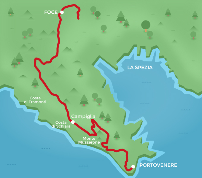
The Poets’ Trail
- Alta via del Golfo
- Difficulty 2
- Time 6h00′
- Length 18 km
The cuisine of Porto Venere and the islands of the archipelago is a triumph of seafood of all kinds, especially mussels, offered as seasoning, appetizers or as the tastiest of main courses, alla marinara or stuffed. “Muscoli” as they are called in La Spezia’s gulf area, come from the mussel farms just a few tens of metres from the coast in the PortoVenere channel. For a good day’s walk, we leave the town going up the steps to the right of the town’s gate, once the only way to get through the splendid row of buildings. Following the red and white markers of the Alta Via del Golfo which will accompany us the entire way, we go uphill towards Campiglia through the Porto Venere regional nature park. Along the way we can enjoy the breathtaking views of the Monte Muzzerone cliff and the islets of Palmaria and Tino, gaze with amazement at the vineyards in the valley of Albana and be fascinated by the terraced coast of Schiara, with its wine cellars clinging to the slopes between land and sea. Continuing along an old trail along the ridge and surrounded by woodland, we reach the village of Biassa, whose inhabitants are said to possess two houses: one in the village and one on the other side of the mountain, on the precipitous coast of Tramonti, where they have been growing grapes for centuries.
Then we continue along the trail with an alternation of uphill and downhill stretches leading to the Passo della Foce, which offers a view of the city of La Spezia and the entire gulf. From this point on we can choose from among many different paths leaving the high road and going down to La Spezia, but if we continue along the trail we can visit the parish churches of Marinasco or the hamlets of Sarbia and Valeriano: it is a very relaxing, even contemplative, part of the trail offering excellent views of La Spezia’s inlets and hinterland. La Spezia is the provincial capital offering a wealth of services. Its origins are remote, but in the last two centuries the city has grown and changed its appearance.
The Genoese domination in the past did not allow this small coastal settlement to develop, but the change came with the arrival of Napoleon who decided to build an arsenal in the gulf. Today, the city offers a combination of excellent museums and buildings in the Art Nouveau style, with its old centre reserved to pedestrians and full of life, especially in the summer evenings. Besides all the dishes of the Ligurian cuisine (from the green pesto sauce to the focaccia) in La Spezia’s pizzerias we can enjoy the farinata, a crisp puff pastry made with chickpea flour and olive oil, while there are still many inns serving mesciua, a typical soup with chickpeas, cannellini beans, dried broad beans, grass peas and emmer, with a pinch of black pepper and a trickle of extra virgin olive oil.
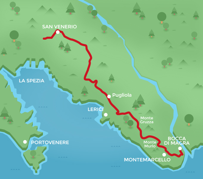
From La Spezia to the Magra River, walking above the sea
- Alta via del Golfo
- Difficulty 2
- Time 6h30′
- Length 21 km
The urban fabric of La Spezia shows its development in three quite different periods. The old medieval nucleus is surrounded by the orthogonal city built in the 19th and 20th centuries. The eastern part, which has grown in the last sixty years, is indicative of the convulsive development of our times. Just as variegated is the cuisine we can scent in the houses and restaurants of the centre, where historical inns faithful to tradition alternate with restaurants offering the best Italian cuisine and pubs at their best when the time comes for aperitifs. To reach the Magra, we walk to San Venerio, the starting point for our excursion along the high Alta Via del Golfo in the direction of Bocca di Magra. In this stretch we can see vineyards cultivated everywhere, albeit sporadically: every vegetable garden has its vines and every house has its small wine cellar. This is the spirit from which come the many labels of the excellent ‘Golfo dei Poeti’ PGI wines. Now we go slightly uphill to the Cisterna Pass and then down towards the village of Pugliola.
In this stretch, the view is once again spectacular: in the background to the right we can see the Genoese castle of Porto Venere with the islets of Palmaria, Tino and Tinetto, while in the foreground rises the village of Lerici whose imposing tower once represented the ramparts of the possessions of the city of Pisa in this land. And Lerici is the village that at the end of each summer is transformed into a sort of capital of Liguria’s seafood cuisine with the Mytiliade festival, a great cultural and gastronomic appointment at the centre of which are mussels, the theme of conferences, excursions, studies and the main ingredient of recipes. Leaving Lerici behind us, we go uphill to Monte Gruzza where we enter in the Montemarcello Regional Nature Park. When we reach the top of Monte Murlo we can visit the botanical garden with its wild Mediterranean bush and gaze in awe at the 360-degree panorama that greets us: a view that includes the mouth of the Magra River and the jagged peaks of the Apuan Alps. Going on, we pass by the ancient village of Montemarcello, whose name apparently comes from that of the Roman consul Claudius Marcellus. The hamlet deserves close inspection to find evidence of its different periods: over the century it has never lost its importance owing to its enviable position and mild climate. Finally, we go through a stand of holm oak and then downhill to the village of Bocca di Magra at the mouth of the river.
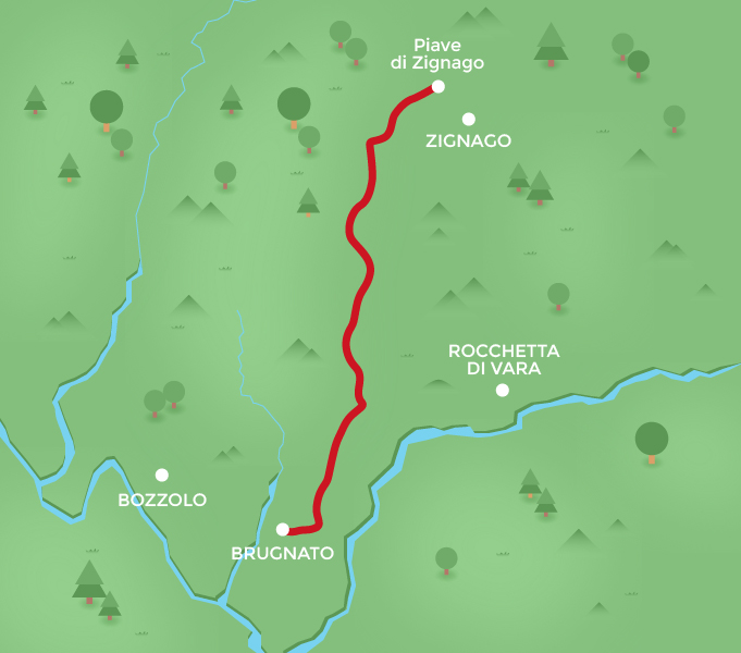
From Brugnato to Zignago’s parish church
- Brugnato – Zignago
- Difficulty 2
- Time 2h40′
- Length 5,82 km
A town of very ancient origins on the left bank of the Vara River, today Brugnato is one of the most visited localities of the Val di Vara owing not only to its cultural heritage but also to its traditional products, the excursions provided by the trails and surrounding woodlands and the possibility of experiencing the thrill of rafting with local experts.
In the year 999 AD, Brugnato was granted the title of city and today it is on the list of Italy’s most beautiful villages. Its centre is elliptical in shape and surrounds the bishop’s citadel as a circular fortified town. Brugnato’s cuisine is outstanding: it offers typical cheeses made in the local dairy and cold meats produced by many small sausage and salami makers. Besides the omnipresent “focaccia” and rice and vegetable pastries, the local bakeries also produce canestrelli brugnatesi, sweets made with sweet dough and flavoured with wild fennel, one of the favourite delicacies of film director Mario Soldati.
In the many restaurants lining the caruggi, the old town’s narrow streets, we can enjoy typical Ligurian dishes. For those who visit Brugnato with the idea of stretching their legs on the highlands above the centre of town, we recommend a long walk to the parish church of Zignago, an ancient suburb where sheep-breeding is still widespread. The trail is marked 18/a.
To reach it, follow the Via Macero, in the western part of Brugnato. After almost 200 metres we come to a crossroads where we leave the main road by turning right into the Via Bozzolo.
The paved road goes up to a crossroads leading to a small cemetery. On leaving the Via Bozzolo where there is a small shrine dedicated to Saint Anthony, we take a rather narrow road that goes through vegetable gardens and pastures. With a holiday farm on our left, we go up to a small saddle and then downhill. The dirt road goes through a landscape featuring low and sparse vegetation. Then we go uphill along the so-called via di boeu, so named because it was used by the people of Zignago to take their oxen to market. Farther on, the road crosses trail 8, known as the Via da Tramonte (the northern trail). We continue uphill along a road that goes through a thick stand of pine trees up to the top of the Taramaschi coast, where the mule track turns into an wellkept dirt road. From here we continue along apparently flat ground that circles Monte Zignago and then goes down to Zignago’s parish church.
On the Pilgrims’ Trail
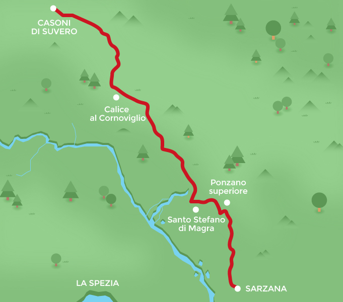
- Casoni – Sarzana
- Difficulty 1
- Time 11h30′
- Length 34,1 km
We travel to Casoni di Suvero by public transport, where we begin our trek. If there is time for a meal it is certainly a good idea to stop at one of the many typical restaurants or holiday farms where we will find outstanding dishes with mushrooms, chestnuts, game and cheeses to enjoy with honey from the hives found everywhere in these valleys.
Setting out, we leave behind the vast pine wood that characterizes the suburbs of Casoni and enter the cartway with the red and white AV marker which takes us to the slightly higher altitude of 1042 metres at the Sella di San Genesio. From here on the road to Sarzana is almost all downhill.
Crossing large pastures framed by broom bushes alternating with more wooded areas, we can enjoy more than one beautiful view of the village of Calice al Cornoviglio with its imposing castle rising above; by going a little way off the main path we can admire Monte Cornoviglio, which overlooks the Val di Vara, the Lunigiana region, the Gulf of la Spezia and the Apuan Alps. Continuing along the old muletrack we reach Monte Alpicella, almost entirely covered by pine trees, which were planted at the beginning of last century to block erosion caused by previous deforestations.
Along the descent towards the Valico dei Solini, the road turns into a narrow path for a short stretch, where oaks and chestnut trees to keep us company along the way. On the right towards the valley appears Bolano.
On reaching Tirolo after passing olive groves and vineyards scattered here and there, we leave the Alta Via and continue along the paved road in the direction of Santo Stefano Magra: right after the bridge over the river we turn and take the scenic road that follows the river.
Here we come to uncontaminated meanders populated by many waterfowl. We approach the centre of the village, where the S4 trail starts. In little more than an hour it will take us to Ponzano Superiore, a small town with ancient origins, perhaps dating back to Roman times. Some believe it derives from the name of the Roman consul Caius Pontius Ligo. It is certainly worth a visit owing to its cultural heritage and cuisine. Since 1975 this is where the Sagra della Scherpada takes place; it is the festival of traditional vegetable pastries, with the consumption of thousands of these delicacies which are a must for visitors. From Ponzano we begin to follow the Via Francigena, which leads down towards Sarzana.
At the halfway point we come to the remains of the Castello della Brina. This stronghold was once important in controlling and protecting pilgrims and collecting tolls. A little farther on we come to the outskirts of Sarzana, a town with a rich heritage and many vestiges not only of its history. In the cafes and restaurants of its well-maintained old centre we can enjoy the typical Ligurian and Lunigiana cuisine, but the dish that stands out in Sarzana is the spongata, a sweet pastry with fruit and jam.


